The hydraulic rigs and tieback drills we mobilize across Tulsa County are configured specifically for the sedimentary sequences that dominate the region. When the auger hits the Pennsylvanian shale at 15 to 25 feet, the torque reaction tells us more than any desktop study ever could. Working between the Arkansas River terraces and the limestone benches east of downtown, we have learned that a deep excavation in Tulsa is never a textbook case. The shales can be competent as temporary berms but degrade rapidly with moisture, and the overlying silty clays often contain perched groundwater that surprises even seasoned contractors. A CPT test pushed through these transitional zones gives us a continuous profile of tip resistance and pore pressure, data that becomes the backbone of the bracing design.
A Tulsa excavation deeper than 12 feet almost always intersects the shale interface, and that contact zone governs both the bracing loads and the dewatering strategy.
Methodology and scope
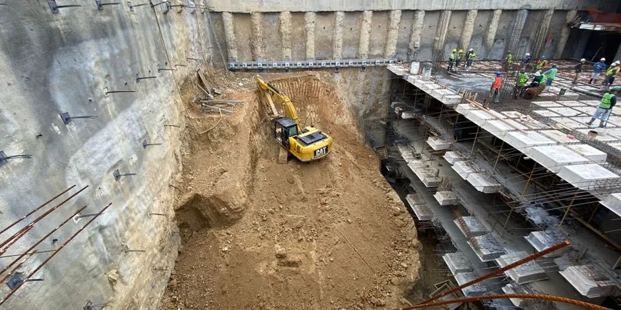
Local considerations
IBC Chapter 33 and ASCE 7 Section 12.13 set the baseline for excavation safety, but in Tulsa the real risk multiplier is the unpredictable weathering profile of the shale bedrock. When the Chat Formation or Seminole shale is exposed to air and moisture for more than 48 hours, slaking can reduce the unconfined compressive strength by 40 percent or more, turning a competent bench into a raveling hazard. We see this most often during the spring rainy season, when excavation sides that looked stable on a Friday come Monday morning show tension cracks behind the soldier piles. The design must therefore specify short exposure windows, immediate shotcrete facing, or pre-treatment with penetrating grout. Adjacent settlement is another critical concern in older districts like Brady Heights, where unreinforced masonry foundations from the 1920s sit within the influence zone of a 30-foot cut and require solid deformation modeling.
Applicable standards
IBC 2021 Chapter 33: Safeguards During Construction, ASCE 7-22 Section 12.13: Earth Retaining Structures, FHWA-NHI-10-024: Earth Retaining Structures and Excavation Support, ASTM D5092: Design and Installation of Groundwater Monitoring Wells, OSHA 29 CFR 1926 Subpart P: Excavations
Associated technical services
Shoring System Design
Complete design of soldier pile and lagging, secant pile, or diaphragm walls including structural member sizing, embedment depth verification, and tieback spacing optimized for Tulsa soil stratigraphy.
Dewatering and Groundwater Control
Design of deep well, wellpoint, or eductor systems based on in-situ permeability testing and the perched water conditions common in the Arkansas River terrace deposits.
Construction-Phase Monitoring Plan
Specification of inclinometers, settlement points, and vibration monitoring thresholds for projects adjacent to sensitive structures in historic Tulsa neighborhoods.
Typical parameters
Frequently asked questions
What is the typical cost range for geotechnical design of a deep excavation in Tulsa?
Based on recent projects in the Tulsa area, the geotechnical design scope for a deep excavation typically falls between US$1,920 and US$8,760, depending on excavation depth, shoring complexity, and the number of soil layers requiring laboratory characterization.
How do Tulsa's shale formations affect excavation support design?
The Pennsylvanian-age shales found in Tulsa, particularly the Seminole and Chat formations, exhibit significant slaking when exposed to moisture. Our design approach includes specifying short exposure times for unsupported cuts, immediate application of shotcrete facing, and conservative selection of long-term strength parameters based on slake durability testing.
What dewatering methods work best in the alluvial soils near the Arkansas River?
In the river terrace deposits west of downtown Tulsa, we typically design wellpoint systems for excavations up to 20 feet and deep wells for cuts exceeding that depth, always verifying the design with pumping tests that account for the seasonal fluctuation of the Arkansas River stage.