Tulsa sits at 722 feet above sea level on the Arkansas River’s floodplain deposits, where native soils shift from lean clays to silty sands across short distances. The city’s 2024 building permit activity topped 4,200 new starts, putting real pressure on compaction QA. We run the sand cone test per ASTM D1556 to verify field density on backfill lifts, utility trench reinstatement, and pavement subgrade across Tulsa County. The method gives a direct, repeatable measurement of in-place wet density, and paired with a lab moisture content, we deliver dry density and percent compaction within 24 hours of field work. In areas like Broken Arrow or west Tulsa where fill materials vary from weathered shale to river sand, Proctor tests establish the reference maximum dry density we measure against on every job.
A sand cone test gives you the number that matters most: percent compaction, right behind the compactor, before the next lift goes down.
Methodology and scope
Local considerations
Tulsa’s active geotechnical hazards are tied to expansive lean clays in the Fayetteville Shale-derived residuum and loose alluvial sands along the Arkansas River corridor. Undetected low compaction in these soils leads to differential settlement in slab-on-grade foundations and pavement edge drop-off within three to five wet-dry cycles. In trench backfill under roads, poorly compacted lifts create longitudinal depressions that pond water and accelerate base failure. The sand cone method directly measures the in-place density before these problems take root. Skipping field density verification on a single critical lift can shift liability entirely onto the earthwork contractor when cracks appear. Our technicians document each test with GPS coordinates, lift thickness, and material description, building a defensible record that meets City of Tulsa public works inspection requirements.
Applicable standards
ASTM D1556-15e1, AASHTO T-191, ASTM D698 / D1557 (Proctor reference), City of Tulsa Standard Specifications Section 02300
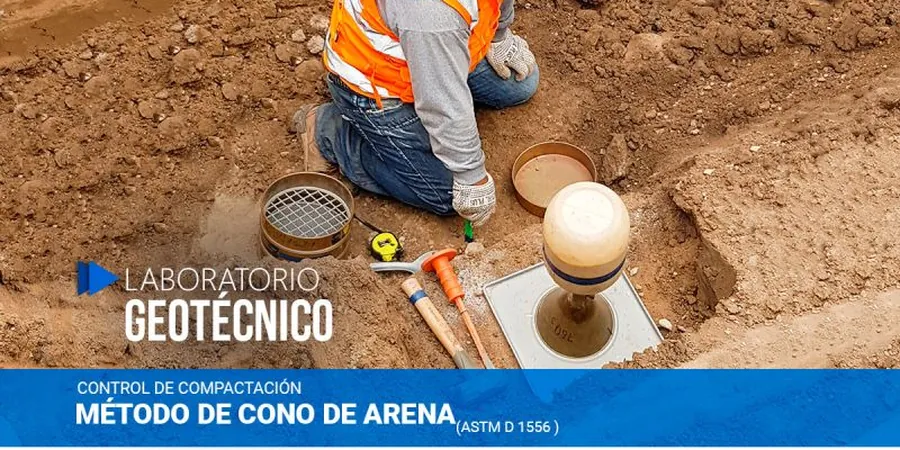
Associated technical services
Field Density by Sand Cone
On-site density test at any accessible depth up to 12 inches. Includes hole volume calculation, wet density, and moisture content determination in our Tulsa lab.
Proctor Compaction Curves
Standard or modified Proctor per ASTM D698/D1557 on your project soil. Establishes the target maximum dry density and optimum moisture content for compaction verification.
Compaction Compliance Reports
Compiled field reports with test locations plotted on site plan, percent compaction per lift, and pass/fail criteria referenced to project specifications.
Typical parameters
Frequently asked questions
At what frequency should sand cone tests be run in Tulsa?
The City of Tulsa typically requires one field density test per 1,500 square feet per lift for structural fill, and one test per 200 linear feet for utility trench backfill. Project specifications may tighten this to one test per 12 inches of lift thickness in critical zones.
What is the typical cost for a sand cone density test in Tulsa?
A single field density test with lab moisture content runs between US$90 and US$160 depending on site access and number of tests performed on the same visit. Bulk rates for larger earthwork jobs bring the per-test cost down.
Can you use the sand cone method on gravelly soils common in northeast Oklahoma?
ASTM D1556 limits the method to soils with maximum particle size under 1.5 inches. For material with coarser gravel, we recommend a drive cylinder or nuclear gauge test, or we can perform a sand cone with a larger hole and proctor correction for oversized particles.
How soon after compaction can the test be run?
Immediately. The sand cone method does not require curing or waiting time. We excavate the test hole, run the sand volume measurement, and seal the soil sample on the spot. Lab moisture determination is completed overnight with results emailed the next morning.
What documentation do you provide for City of Tulsa inspections?
Every report includes test location GPS coordinates, lift number and thickness, field wet density, lab moisture content, dry density, percent compaction relative to the specified Proctor standard, and a pass/fail statement against project specifications.