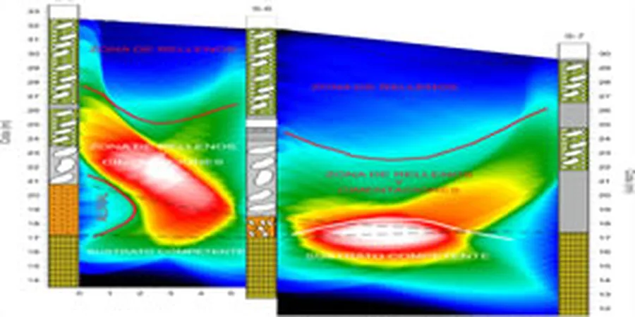
Tulsa’s built environment expanded rapidly after the 1901 oil strike at Red Fork, pushing development across the Arkansas River floodplain and into the limestone uplands. That history left a patchwork of fill, alluvium, and weathered shale beneath today’s structures. Our team uses seismic tomography to image those transitions without relying on scattered borings alone. The method measures P-wave and S-wave travel times, then inverts them into 2D velocity cross-sections that reveal bedrock depth, fracture density, and stiffness contrasts critical for foundation bearing capacity. For near-surface voids in the Boone Formation, we often pair the tomographic profile with a targeted test pit investigation to calibrate velocity anomalies against exposed rock conditions.
The Boone Formation’s karst features routinely produce velocity inversions that only tomographic inversion can resolve — standard refraction layering misses them.
Methodology and scope
Local considerations
The most common call we get in midtown Tulsa involves differential settlement near abandoned coal mine entries or unmapped solution cavities. The old Dawson coal seam was mined at shallow depths until the 1950s, and subsidence features appear decades later, often triggered by heavy rain. Seismic tomography detects these hazards as low-velocity zones that interrupt the normally continuous limestone reflector. One recent project along the Riverside corridor identified a 15-ft-wide void at 30-ft depth that exploratory borings had missed by 8 ft. Without the tomographic profile, the structural slab would have spanned an active collapse zone. The IBC requires competent bearing verification, and seismic methods provide that spatial continuity that isolated borings cannot.
Applicable standards
ASTM D5777-18 (seismic refraction), ASCE 7-22 Chapter 20 (site class from Vs), IBC 2021 Section 1803 (foundation investigation)
Associated technical services
2D Seismic Refraction Tomography
Full-array acquisition with 24 or 48 channels, inverted to produce continuous velocity cross-sections for rippability classification and bedrock profiling.
Seismic Reflection Profiling
Common-midpoint (CMP) acquisition for deeper targets, useful where the water table or thick shale masks the limestone reflector in refraction data.
Integrated MASW and Refraction
Simultaneous acquisition of surface-wave and body-wave data to derive both Vs30 for ASCE 7 site class and a P-wave tomography model from the same spread.
Typical parameters
Frequently asked questions
How deep can seismic tomography image beneath a Tulsa site?
With a standard 230-ft geophone spread and sledgehammer source, we reliably image to 80–100 ft in dry limestone. Depth increases to roughly 150 ft when using a weight-drop source. For deeper targets, we recommend combining surface tomography with downhole receivers in a borehole.
What does a seismic tomography survey cost in the Tulsa area?
A typical 2D refraction tomography line with 24 channels and one source position runs between US$2,680 and US$5,380, depending on spread length, terrain access, and whether shear-wave acquisition is included. Multi-line projects benefit from reduced mobilization cost per profile.
Can tomography distinguish between weathered shale and sound limestone?
Yes. In the Tulsa geologic section, the velocity contrast is clear: weathered shale typically registers 1500–1800 m/s, while competent Boone Limestone exceeds 3000 m/s. The tomographic inversion resolves the transition zone, which is critical for determining socket depth in drilled shafts.